3d shapes - detection and or measurement

Detection or imaging of three-dimensional (3d) objects requires a number of views be made to establish three dimensions of a target.

Capacitive and electric field sensing techniques use a sensor array comprising multiple electrodes to obtain data for image mapping. The greater the density of data collected the greater the resolution of the resulting image map.
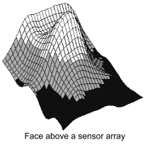
Face above a sensor array

Radar and Sonar based imaging achieves 2 and 3 dimensional views by multiple views, using the same transducer rather than a sensor array, with each view taken by the transducer separated by a different viewing angle.

A characteristic of capacitive and electric field image mapping techniques is non-invasive mapping. Capacitive and electric field sensor arrays can project fields over an air gap which penetrate materials to map objects beneath the surface. This non-invasive mapping is also possible with "ground radar" when close proximity to the surface is achieved.

Radar image mapping is better suited to long-range operation through air and Sonar image mapping best suited to long-range operation through water.

Ultrasound image mapping, using low frequency sound waves at a low range, can map embedded objects but requires an acoustic coupling with the surface to achieve this. Gel is used for example to gain an acoustic coupling between an ultrasound probe and a pregnant mothers stomach so that ultrasound systems can create an image of a baby while in its mother's womb.

When capacitive and electric fields are used for image mapping, multiple sense electrodes are typically built into a sensor array where very low parasitic capacitance of each electrode and circuit is required to minimise signal loss.
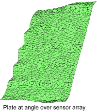
Plate at an Angle over a sensor array

Processing electronics deal with the multiple inputs from the sensor array to produce an image map of the target which may be intended for human or automatic (machine) evaluation.

If destined for human evaluation the system collates and presents the data to a screen. Various modes can be used but humans will use their own reasoning to decide what an object is and therefore what action might be appropriate.

If destined for automatic machine evaluation, the sensing and control system must be programmed to interpret the data gathered.

This may take the form of identifying if certain shapes are present, determining specific characteristics and making particular measurements

Examples include the measurement of human feet, or detection of land mines under the soil.

In the case of measuring feet: specific features of the human foot must be measured which will correspond to a shoe size.

In the case of landmines: matching 3d shapes found to known mines in a stored database will allow identification of which landmine has been found.